The highest mountain in Alberta is Mount Columbia (3,747 metres) located on the boundary with British Columbia in Jasper National Park of Canada, a UNESCO World Heritage site. It received its name in 1899 from the Columbia River, itself named in 1792 by Captain Robert Gray, an American, for his vessel, the Columbia.
Mount Columbia. 3,747 metres. 12,293 feet
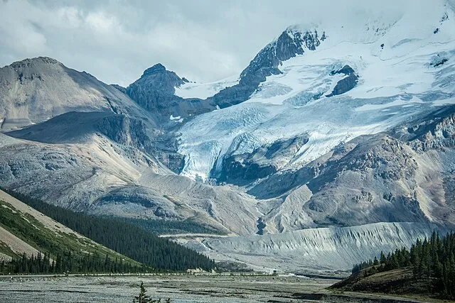
Author: m01229 from USA – wikimedia.org
Approach is through the Columbia Ice fields. First summit in the Expedition.
| Attribute | Details |
|---|---|
| Altitude | 3,747 m, 12,293 ft |
| Location | 52° 09’ 00” N – 117° 27’ 00” W |
| NTS Map | O83C03 Columbia Icefield |
| Calendar | March, April, May |
| Parks | Jasper National Park |
| Fast Facts | CAPITAL: Edmonton, Alta PROVINCIAL FLOWER: Wild Rose PROVINCIAL BIRD: Great Horned Owl PROVINCIAL TREE: Lodgepole Pine |
| Web Links | peakbagger.tripod.com peakfinder.com peakware.com forums.climbing.com travellersvoice.com summitpost.org |
History
Alberta’s highest mountain is Mount Columbia (3,747 metres) located on the boundary with British Columbia in the Rocky Mountains. Named by J. Norman Collie in 1898 it received its name from the Columbia River, itself named in 1792 by Capt. Robert Gray, an American, for his vessel, the Columbia who first ventured over a dangerous sandbar and explored the lower reaches of the river.
Located on the continental divide at the head of the Athabasca River Valley southwest of Columbia Glacier; Sir Winston Churchill Range, Jasper Park, Alberta/BC border. Mount Columbia lies on the northern edge of the Columbia Icefield, 9.7 km southwest of Snow Dome that may be seen from Highway #93 N at the Icefields Centre on Sunwapta Pass.
Routes
First ascended in 1902 by James Outram, guided by Christian Kaufmann.
East Face (Normal Route) II
The classic ski route is up the Athabasca Glacier, and onto the Columbia Icefield, camping in the “trench” at the head of the Columbia Glacier. Roped ski-ing, and whiteout navigation are essential techniques. The peak usually doesn’t require crampons.
A non-technical route
Leading to the highest summit in Alberta and a popular route in the spring when the skiing on the Icefields is at its best. It is usual to climb the E face from a camp on the Icefield, usually in the “Trench”, a large east-west depression in the Icefield at the base of the face. It involves a 450 m climb of up to 45-degree snow and/or ice. Strong winds often blast the upper reaches of the mountain and whiteouts are common.
From the normal base camp at the saddle of the trench, head west for 6 km across a broad ridge to the base of the East Face. The route follows the smooth snow ramp located left of the ice bulges. At the bottom of the 450-m high face, go left for a couple of hundred metres, staying above the lower crevasses but below the upper crevasse. Skirt left of the upper crevasse However; it has been day-tripped from the highway. Dougherty, Selected Alpine Climbs page 204.
The southeast ridge of Mount Columbia
The southeast ridge of Mount Columbia is about the same difficulty as going directly up the East Face. It is mostly a snow scramble, although in places it is necessary to get off the ridge and climb up the steep snow. Starting from the Icefields Parkway, your first job is to get to the “Trench”, by either the Saskatchewan Glacier approach.
North Ridge V 5.7 W3 – A big climb in a remote setting. An excellent route with lots of variety packed into almost 2000 m of climbing.
- Alberta Hwy 93 – Icefield Parkway
- Athabasca Glacier
- 6,700 Climbers parking lot
- 7,400 Brewster Transport area parking lot
- 8,900 3rd Icefield to Columbia Icefield, large trench 7km east of Mt. Columbia camp in or near trench
- West towards Mount Columbia, 4 km W to Base of Summit pyramid
- East face left side summit day gain 3,400/7km
Climate Overview of Mount Columbia
Mount Columbia’s environment is dominated by a subarctic climate, making it imperative for adventurers to be well-informed before setting out. This mountain’s weather can greatly differ with elevation and throughout the year, impacting both safety and experience.
Temperature Variations
Temperatures on Mount Columbia tend to be on the lower side, with the altitude bringing cooler conditions. In the peak summer months, which are favored for expeditions, the temperature typically ranges between 5°C and 15°C (41°F to 59°F) at higher elevations. Nights can see temperatures dropping to below freezing levels even during these warmer months. Winter introduces far more severe conditions, with temperatures often sinking below -20°C (-4°F), posing increased risks for any climbing activities.
Snowfall and Best Times for Climbing
The region experiences substantial snowfall from late fall to spring, with the heaviest snow typically from November to May. The deep snow impacts access and increases the potential for avalanches. Despite this, the late spring months of March to May are often seen as the optimal time for ascents. During this period, the snow starts to stabilize somewhat, providing safer conditions for climbing, particularly for those who prefer to ascend on skis.
Visibility and Weather Changes
Visibility on the mountain can be highly variable and can deteriorate rapidly, which is crucial for navigation. Snowfalls can lead to whiteout conditions, while fog tends to be more prevalent in early mornings and evenings. Climbers are advised to plan their ascents early in the day and keep abreast of weather updates to avoid being caught in poor visibility conditions.
Wind Conditions
Winds at higher altitudes on Mount Columbia can be intense, especially near the summit. These strong winds not only make the climb more difficult but also significantly lower the temperature due to the wind chill factor. Suitable windproof clothing and gear are essential for anyone attempting the climb to protect against the harsh conditions.
Preparation and Safety Tips
Late spring is generally the safest time for attempts, when weather conditions tend to be more predictable. Always consult the latest weather forecasts and consider engaging with experienced guides who understand the mountain’s specific climatic challenges.
Understanding and respecting the formidable climate of Mount Columbia is crucial for a successful and safe climbing experience. Adequate preparation and choosing the appropriate time for an expedition can significantly impact the outcomes of your adventure.
Safety and Conservation Tips for Mount Columbia Visitors
Exploring the rugged terrains of Mount Columbia requires a cautious approach to ensure both personal safety and the preservation of the natural environment. By adhering to best practices for safety and conservation, climbers and hikers can enjoy the beauty of the area responsibly and sustainably.
Safety Precautions
Before embarking on a climb or hike, it is crucial to prepare adequately. Always check the weather forecast and plan your trip during periods of expected good weather. Equip yourself with the necessary gear, including proper footwear, weather-appropriate clothing, navigation tools, and emergency supplies like a first-aid kit and a whistle. It is also wise to inform someone of your travel plans and expected return time.
Steep drops and loose rock can be particularly dangerous, so remain vigilant and keep a safe distance from cliff edges. High altitudes can also pose risks such as altitude sickness; ascend gradually and stay hydrated to help acclimatize your body.
Environmental Impact Reduction
Preserving the pristine nature of Mount Columbia is a collective responsibility. Stick to established trails to minimize disturbance to the surrounding vegetation. When camping, use designated sites to avoid damaging untouched land. Be mindful of all waste—what you carry in, you must carry out. This includes organic waste such as food scraps, which can disrupt local wildlife feeding habits.
Speaking of wildlife, it is important to observe animals from a distance. Feeding wildlife not only alters their natural behaviors but can also endanger their health. Store food securely and dispose of all waste in bear-proof containers where available, or pack it out to prevent attracting animals.
Fire Management and Resource Conservation
Avoid lighting fires in undesignated areas. If campfires are allowed, use existing fire rings and keep fires small to reduce their impact. Always ensure that fires are completely extinguished before leaving the site. Consider using a portable stove for cooking, which is safer and leaves less of an impact than a fire.
Water sources should also be protected. Use biodegradable soap for washing and do so at least 200 feet away from streams or lakes to prevent contamination. When using the bathroom outdoors, do so at a similar distance from water sources, trails, and campsites, and bury human waste in a small hole 6 to 8 inches deep.
Respecting Cultural Heritage
Mount Columbia is not only a natural asset but also a place of cultural significance. Respect any cultural or historical sites you encounter; do not disturb artifacts or structures. Educating yourself about the history and significance of the area can enhance your visit and foster a greater appreciation for the mountain’s heritage.
By following these safety and conservation tips, you can help ensure that Mount Columbia remains a stunning and safe environment for all who visit, now and in the future.
Conclusion
Mount Columbia, at 3,747 meters, is the highest peak in Alberta, located in Jasper National Park. The best times for climbing are from March to May, utilizing the East Face route, which is popular for ski ascents. Weather conditions can be extreme, with subarctic climates influencing safe climbing times and necessary precautions. Climbers should adhere to safety and environmental conservation practices to protect both themselves and the natural landscape. Respecting cultural heritage and minimizing environmental impact are crucial for sustainable exploration of Mount Columbia.
FAQs
When is the ideal season to attempt a climb on Mount Columbia?
The preferred months for climbing Mount Columbia are between March and May. During this period, the snow conditions are generally stable, which is ideal for ski mountaineering.
What factors contribute to the difficulty of the ascent on Mount Columbia?
The ascent is challenging due to Mount Columbia’s high elevation, the cold subarctic weather conditions, and the likelihood of sudden severe weather changes, including strong winds and heavy snowfalls.
How can I reduce my environmental footprint while climbing Mount Columbia?
To lessen environmental impact, climbers should adhere to trails, use established campsites, carry out all trash, use eco-friendly products, and ensure that wildlife is not disturbed or fed.
Does Mount Columbia hold any specific cultural value?
Indeed, Mount Columbia is a site of considerable cultural value, located within Jasper National Park—a recognized UNESCO World Heritage site. The area is steeped in natural and historical significance, reflecting the heritage of its indigenous peoples and the broader Canadian cultural landscape.