It’s 2017 … which means that it’s Canada’s 150th Birthday! And, as luck would have it, this is also the Summits of Canada team’s final Canadian highpoint! This year the team will be tackling Barbeau Peak in Nunavut during the month of June.
Situated at the tip-top of Canada, Barbeau is about as remote a location as you can find anywhere on the planet, let alone in the vast Canadian wilderness.
This 2,616 metre, (8,583 feet) summit sits stoically in the middle of Ellesmere Island’s Quttinirpaaq National Park and crowns the northern part of Canada’s Arctic Archipelago.
To share in the experience and to learn about this magnificent and truly unique Canadian location, indigenous culture and more, take advantage of CanaTrek’s pretrip online & interactive “Exploring by the Seat of Your Pants” Hangout Sessions that starts on May 18th.
With an aim to help increase your geographic knowledge, a number of great Canadian Geographic lesson plans are also provided.
On top of that, there is also a fun and exciting CanaTrek Prayer Flag 150 Contest which students can enter to share and take part in Canada’s 150th celebrations.
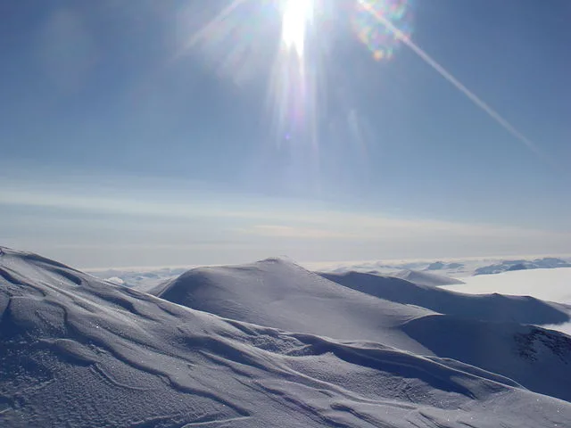
Author : FiLo X – wikimedia.org
Barbeau Peak Agenda/Itinerary
This year’s adventure learning trip includes an Ellesmere Island Traverse and Barbeau Peak Summit Expedition, and is scheduled to take place from:
June 16 – June 29, 2017
Team Members:
- Len Vanderstar
- Brian & Laura Friedrich
- Eric Gilbertson
- Serge Massad
Expedition Schedule
June 14 – All team members have arrived in Resolute
June 15 – Buffer/preparation day / gear check
June 16 – The team takes flight by ski plane to the ice cap very close to Barbeau
June 17-20 – Approach and Summit of Barbeau Peak
June 20-29 – Descend from the ice cap and trek out to Tanquary Fjord or Lake Hazen landing strips (each about 50-60 miles away, mostly on glacier, but some tundra)
June 30 – Flight back to Resolute
July 1 – Flights home from Resolute
About Quttinirpaaq National Park
The following provides a snapshot of interesting details regarding Quttinirpaaq National Park and the iconic landscapes and areas that the Summits of Canada team will travel through. (Note – information is compliments of Parks Canada’s Quttinirpaaq Visitor Information Package.)
There are four national parks in Nunavut representing various examples of Canada’s 39 natural regions – Quttinirpaaq (Eastern High Arctic), Sirmilik (Eastern Arctic Lowlands), Ukkusiksalik (Central Tundra) and Auyuittuq (Northern Davis).
Unique Features of Quttinirpaaq
Quttinirpaaq, Inuktitut for “Land at the Top of the World”, is a vast, ancient, sprawling landscape in the extreme high Arctic that has the expected: ice caps enclosing mountains, kilometres thick glaciers, worn mountains, and sparse tundra. But it also has the unexpected: the highest mountain in eastern North America (Barbeau Peak) and a thermal oasis in the Lake Hazen area. Lake Hazen, one of the largest and deepest lakes in the world above the Arctic Circle, has remarkably lush vegetation and supports higher densities of wildlife than the rest of the park.
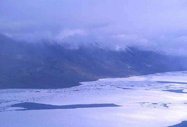
Author – Ansgar Walk – wikimedia.org
Located in Canada’s Nunavut Territory, Quttinirpaaq National Park was established as a national park reserve in 1988 and was established as an official national park in 1999. Canada’s second largest national park, Quttinirpaaq, is 37,775 square km in size and is located on Ellesmere Island, and is on the northern tip of the most northerly piece of land in North America.
Inuit Culture: Ancient peoples have a long history on Ellesmere Island, starting with the arrival of the Palaeo-Eskimos about 4,500 years ago, followed by the Last Dorset cultures and the Thule people who arrived during the past thousand years. Archaeological sites give testimony to the resiliency of these people and their ability to survive in this extreme northern climate.
Climate and Weather Patterns
Quttinirpaaq National Park is a polar desert – it is a cold region with little precipitation. Winters are very cold with some of the lowest temperatures recorded in Canada. In contrast, summers, though short, can be surprisingly warm, particularly in the Lake Hazen area. Coastal areas of the park are generally cooler and receive more precipitation than the interior. Winds throughout the park tend to be light, except on the ice caps. There are 24 hours of daylight from May to August and 24 hours of darkness from November to February.
Safety Precautions and Considerations
Emergency Protocols
In the event of an emergency, our team is equipped with well-defined protocols to ensure swift and coordinated response. Each member is trained in first aid and wilderness survival techniques, enabling them to provide immediate assistance if needed. We have established communication channels to quickly alert authorities and request assistance in case of emergencies.
Communication Devices
We utilize state-of-the-art communication devices to maintain contact with our team members and base camp throughout the expedition. Satellite phones, GPS trackers, and two-way radios are among the tools we employ to stay connected and relay important information. These devices enable real-time communication and facilitate coordination, especially in remote and challenging terrain.
Training and Preparedness
Prior to embarking on the expedition, all team members undergo rigorous training to enhance their wilderness survival skills and preparedness for the journey ahead. Training sessions cover topics such as navigation, avalanche safety, cold weather survival, and glacier travel techniques.
Environmental Awareness
In addition to prioritizing the safety of our team members, we are committed to minimizing our environmental impact during the expedition. We adhere to Leave No Trace principles, ensuring that we leave the wilderness pristine and undisturbed.
Weather Monitoring
We closely monitor weather forecasts and conditions throughout the expedition to ensure the safety of our team members. Unpredictable weather patterns are a constant consideration in the Arctic, and our team remains vigilant to changing conditions. We adjust our itinerary and activities as necessary to avoid hazardous weather and minimize risk.
Continuous Evaluation
Our safety protocols are subject to continuous evaluation and improvement to ensure their effectiveness. We conduct regular safety briefings and debriefings to review our procedures and identify areas for enhancement. Feedback from team members and experienced guides informs our safety practices, allowing us to adapt to evolving challenges and conditions.
Conclusion
CanaTrek offers pre-trip online sessions and Canadian Geographic lesson plans to enhance geographic knowledge and learn about indigenous culture. The expedition prioritizes minimizing environmental impact by adhering to Leave No Trace principles and responsible waste management practices. Rigorous safety protocols, including emergency response plans, communication devices, comprehensive training, environmental awareness, and continuous evaluation, ensure the well-being of team members throughout the expedition.
FAQs
What educational opportunities are available during the expedition?
CanaTrek offers pre-trip online sessions and Canadian Geographic lesson plans to enhance participants’ geographic knowledge and learn about indigenous culture.
How does the expedition prioritize environmental stewardship?
The expedition prioritizes minimizing environmental impact by adhering to Leave No Trace principles and responsible waste management practices.
What safety measures are in place during the expedition?
Rigorous safety protocols are in place, including emergency response plans, communication devices such as satellite phones and GPS trackers, comprehensive training in wilderness survival skills, environmental awareness, and continuous evaluation of safety procedures.