Embark on an adventure to Mount Carleton, where towering peaks meet breathtaking landscapes, promising an unforgettable journey into the heart of New Brunswick’s wilderness.
Author: Greffiere adjointe – wikimedia.org
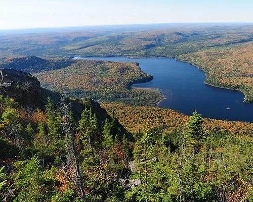
With its summit soaring at 817 meters, Mount Carleton stands as the highest mountain in New Brunswick, nestled within the stunning Mount Carleton Provincial Park.
Named after Thomas Carleton, the province’s first lieutenant-governor, this majestic peak beckons adventurers to explore its accessible wilderness, offering a haven of tranquility away from the hustle and bustle of nearby towns and villages.
Mount Carleton. 817 metres.2,680 feet
| Attribute | Details |
|---|---|
| Altitude | 817 m, 2,680 ft |
| Location | 47° 23′ 00″ N – 66° 53′ 00″ W |
| NTS Map | 021 O07 Nepisiguit Lakes |
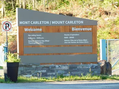
| Calendar | May 15 – September 5 |
| Parks | Mount Carleton Provincial Park |
| Fast Facts | CAPITAL: Fredericton, New Brunswick PROVINCIAL FLOWER: Purple Violet PROVINCIAL BIRD: Black-capped Chickadee TREE: Balsam Fir |
| Web Links | www.tourismnewbrunswick.ca www.out-there.com (Listed twice, shown once) |
Аuthor : Jimmy Emerson, DVM – flickr.com
History
In 1899, W.F. Ganong determined New Brunswick’s highest elevation (820 metres) and named it Mount Carleton for Thomas Carleton (1736-1817), the first lieutenant-governor of New Brunswick.
Located in Mount Carleton Provincial Park. Mount Carleton is the highest mountain in the Maritime Provinces. It is located in an accessible wilderness along good paved roads but with no nearby towns or villages. This accessible isolation is a large part of its appeal.
The park is located in the northern extension of the Appalachian Mountains. Aside from the 820m Mount Carleton, the park has several other significant peaks including Mount Bailey, Bald Mount Brook, Mount Head and the well know Sagamook, all of which have trails around or over them.
Routes
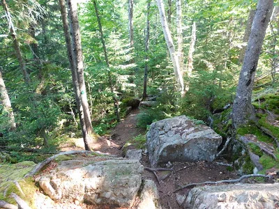
Mount Carleton Trail is a moderate hike of 4.4km. A fairly easy trail that takes you to the peak of Mount Carleton, which at 820 metres it is the highest point in the Maritime Provinces. From the top you have a spectacular view of a number of other peaks in the area and views into Maine and Quebec. The trail should take about 1 1/2 hours from the east, or 2 hours from the trail on the west side (the fire road).
Essential Safety Tips for Mount Carleton Provincial Park
Embarking on an adventure in Mount Carleton Provincial Park promises breathtaking landscapes and thrilling experiences, but safety should always remain a top priority. Here’s how you can ensure a secure and enjoyable visit:
Stay Hydrated and Energized
As you delve into the park’s trails and vistas, remember to keep yourself hydrated and nourished. Carry an ample water supply and energy-rich snacks to sustain your energy levels during your exploration. By staying hydrated, you’ll be better equipped to tackle the park’s challenges while enjoying its beauty.
Respect Wildlife and Their Habitat
While encountering wildlife can be an enchanting part of your journey, it’s crucial to maintain a safe distance and avoid disturbing their natural habitat. Refrain from feeding or approaching animals for photographs, as this can disrupt their behaviors and pose risks to both you and the wildlife. Keep food securely stored to prevent attracting unwanted attention from curious critters.
Stay on Designated Trails
Before venturing out on your hike, acquaint yourself with the park’s trail maps and route descriptions. Stick to marked trails to avoid getting lost and minimize the impact on the delicate ecosystem. Pay heed to trail markers and signs, and consider carrying navigation aids like a compass or GPS device for added assurance.
Be Prepared for Weather Changes
Mountains are notorious for their unpredictable weather patterns, so it’s essential to equip yourself for varying conditions. Dress in layers to adapt to temperature fluctuations and carry waterproof gear to shield yourself from unexpected rain showers. Check the weather forecast beforehand and remain flexible with your plans to accommodate any changes in weather.
Respect Park Regulations and Leave No Trace
Ensure a harmonious visit by adhering to park regulations and practicing Leave No Trace principles. Respect posted signs regarding trail closures, wildlife conservation areas, and camping guidelines. Dispose of waste responsibly and leave nature undisturbed, allowing future generations to relish the park’s splendor.
By embracing these safety tips and responsible practices, you’ll not only safeguard your well-being but also contribute to the preservation of Mount Carleton Provincial Park’s pristine wilderness for all to enjoy.
Cultural and Historical Significance
Indigenous Legacy
The lands surrounding Mount Carleton bear witness to millennia of Indigenous presence, echoing with the whispers of traditions, ceremonies, and stories passed down through generations. For the Mi’kmaq, Wolastoqiyik (Maliseet), and Peskotomuhkati (Passamaquoddy) peoples, these sacred lands are repositories of ancestral wisdom and spiritual connection.
Pioneer Chronicles
The emergence of European settlers heralded a new chapter in the region’s history, as intrepid pioneers ventured into the untamed wilderness in search of opportunity and adventure. Their resilience in the face of adversity, etched in the remnants of frontier settlements and logging camps, epitomizes the indomitable human spirit.
Exploring Historical Landmarks
Mount Carleton Provincial Park beckons adventurers to uncover the hidden gems of its storied past, from ancient Indigenous gathering sites to the weathered relics of early settler homesteads. Each historical landmark serves as a poignant reminder of the triumphs and tribulations that have shaped the landscape over centuries.
Cultural Festivities
Throughout the year, Mount Carleton and its surrounding communities come alive with the vibrant rhythms of cultural celebrations and festivals:
- Indigenous Powwows: These events are significant cultural gatherings for the Indigenous communities. Powwows include traditional dancing, drumming, and singing, and serve as a celebration of indigenous cultures and a way to pass down traditions and stories from one generation to the next. They honor the age-old customs and practices of the local First Nations.
- Folk Music Gatherings: These gatherings are celebrations of local heritage through music. They typically feature performances of traditional folk music, showcasing both historical tunes and contemporary compositions that reflect the region’s musical legacy. Such events not only entertain but also preserve and promote the unique cultural identity of the area.
- Cultural Festivals: Various other cultural festivals occur, highlighting the diverse background of the communities around Mount Carleton. These festivals might include art exhibits, craft markets, culinary events, and more, each contributing to the rich cultural tapestry of the region.
By immersing oneself in the rich tapestry of cultural and historical narratives woven into the fabric of Mount Carleton and its surroundings, visitors embark on a transformative journey of discovery, empathy, and reverence for the enduring legacy of those who have walked these lands before.
Conclusion
Rising majestically to 817 meters, Mount Carleton stands as a beacon of natural splendor, offering a pinnacle of exploration within Mount Carleton Provincial Park. Despite its untamed allure, Mount Carleton welcomes adventurers with open arms, accessible via well-maintained roads that wind through a wilderness sanctuary, providing respite from the chaos of city life. Before setting foot on the trails, ensure your safety by staying hydrated, showing respect to wildlife, following marked routes, preparing for weather shifts, and adhering to park guidelines. Peel back the layers of time to uncover the rich tapestry of cultural and historical narratives surrounding Mount Carleton, from ancient Indigenous legacies to the pioneering spirit of early settlers. Immerse yourself in the diverse landscapes and narratives of Mount Carleton, embarking on a transformative odyssey that fosters a deep connection with the natural and cultural heritage of the region.
FAQs
What are the top attractions in Mount Carleton Provincial Park?
Explore the park’s scenic hiking trails, picturesque viewpoints, tranquil lakes, and abundant wildlife for an unforgettable experience.
How can I access Mount Carleton?
Reach Mount Carleton via well-maintained roads leading to the park entrance. From there, follow designated trails to discover the mountain and its surrounding wilderness.
What safety measures should I take when visiting Mount Carleton?
Prioritize safety by staying hydrated, following marked trails, respecting wildlife, and preparing for changing weather conditions. Familiarize yourself with park regulations before starting your adventure.
What cultural and historical landmarks can I explore in Mount Carleton Provincial Park?
Discover ancient Indigenous gathering sites, remnants of early settler settlements, and other historical points of interest that offer insights into the region’s rich heritage.
Are there any special events or festivals held in Mount Carleton Provincial Park?
Throughout the year, Mount Carleton and neighboring communities host a variety of cultural events and festivals celebrating local traditions. From Indigenous ceremonies to music gatherings, these events provide opportunities to immerse yourself in the region’s vibrant culture.