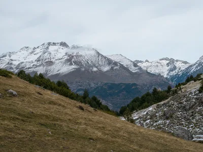
Mt. Caubvick is the highest mountain in the Torngat Mountains, located on the northern tip of Labrador and eastern Quebec called the Ungava peninsula. The mass of Mount Caubvick is on the border between Quebec and the province of Newfoundland and Labrador. The Torngats are part of a 22,000 square kilometer protected wilderness area that is in the process of becoming a National Park. The park is home to one of the largest herds of Caribou on earth (in excess of 300,000), golden and bald eagles, wolves, black bears, the occasional polar bear, peregrine falcons and the endangered Harlequin duck.
Mount Caubvick. 1,652 metres. 5,420 feet
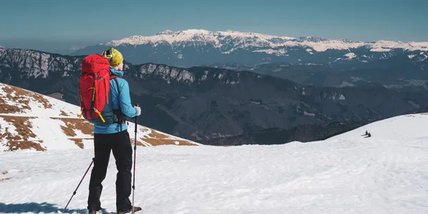
Very remote: access is by float plane or boat, and then a hike in to either a South or North approach
| Attribute | Details |
|---|---|
| Altitude | 1,652 m, 5,420 ft |
| Location | 58° 43′ 00” N, 63° 43′ 00” W |
| NTS Map | O14L13 Cirque Mountain 14 M/4 Nachvak Fiord |
| Calendar | Very limited time, usually best in summer (July & August) |
| Parks | N/A |
| Fast Facts | CAPITAL: St. John’s, Newfoundland PROVINCIAL FLOWER: Pitcher Plant PROVINCIAL BIRD: Atlantic Puffin PROVINCIAL TREE: Black Spruce |
| Web Links | gallery.backcountry.net www.alavigne.net gallery.backcountry.net (duplicate removed) www.peakbagger.com www.summitpost.org |
History
In the Torngat Mountains in Labrador, the range extends northward for 120 m/ 190 km from Hebron Fjord to Cape Chidley, between the Quebec border (west) and the Atlantic Ocean (east). Named from an Eskimo (Inuit) term Torngarsuak, meaning “ruler of all sea animals,” the mountains are sometimes locally referred to as Devil Mountains, or “home of the spirits.” Inuit called it “torngat” after their god of wind and storm.
The peak is located on the peninsula of land that divides the Atlantic Ocean from Ungava Bay. The peak is right on the divide, south of Nachvak Fiord, and north of the Korok River. The peak is one of the few in the area with glaciers. Its northern slopes drain into Nachvak Fiord (Atlantic Ocean), and its southern slopes into the Korak River which flows east to Ungava Bay. It is the highest mountain in both Quebec and Newfoundland Labrador). In Quebec the peak is known as Mont d’Iberville. The peak has three main ridges: The Minaret and Korak, which form the border, and the steep north ridge known as the Newfoundland ridge. Most parties use a rope for the last few pitches.
Before 1971 it was believed that Cirque Mountain was the highest peak east of the Rockies and south of Baffin Island. This was based on a measurement by A.P Coleman, who made the first ascent in 1916. In August 1971 it was christened “Mont d’Iberville” in honor of Pierre Le Moyne d’Iberville. This name angered residents of Newfoundland because he had lead many ruthless expeditions against them, including one in 1696 against the Avalon Peninsula. While still known as Mont I’berville, it was climbed in 1973 by an overland expedition by Goetze and Adler.
Routes
Same as Mount D’Iberville, Quebec. Drive to Goose Bay, Newfoundland, take a PAL flight to Nain and charter a boat to Nachvak Fjord. Requires 2 days of travel and a 7 month advance reservation. Boat would return in 7 days for pickup. Climb to summit would take approximately 4 or 5 days. Estimated cost $1000/return.
Alternative Route
For a different approach and climb, check out the route taken by the CanaTREK Summits of Canada Team in July & August, 2014. This requires flying in to the headwaters of the Koroc River via Twin Otter plane. The flight can be scheduled from Kangiqsualujjuaq (George River). Summit route used the Koroc Ridge, and descent was along the Minaret Ridge. See details including planning resources/guides, photos, and an interactive GIS map (with GPS marked route, topographic and satellite views, etc.).
Safety and Preparedness for Mount Caubvick
Visiting Mount Caubvick involves navigating a remote and challenging environment. Ensuring your safety requires careful preparation and awareness of potential hazards.
Understanding Weather Conditions
The weather on Mount Caubvick can be unpredictable and changes rapidly. Temperatures can vary drastically, with cold nights and potentially warm days during summer. It is crucial to check the weather forecast regularly before and during your expedition. Always prepare for possible sudden weather changes such as fog, rain, or snow, even in summer.
Essential Gear List
Packing the right equipment is key to your safety and comfort on the mountain. Your gear list should include:
- Weather-Resistant Clothing: Wear layers that you can add or remove easily. Include a waterproof and windproof jacket and pants.
- Hiking Boots: Durable, waterproof boots with good ankle support are necessary.
- Navigation Tools: GPS devices, a physical map, and a compass are essential as electronic devices can fail.
- Emergency Shelter: Always carry a lightweight tent or a bivy sack in case you need to stay overnight unexpectedly.
- First Aid Kit: Prepare a kit with bandages, antiseptic, pain relievers, and medication for personal ailments.
- Communication Device: A satellite phone or a personal locator beacon (PLB) can be crucial in emergencies, as cell service is unreliable.
Navigation and Route Planning
Navigation in such a remote area is challenging. Prior to your trip, familiarize yourself with the terrain by studying maps and satellite imagery. Plan your route and share it with someone not on the trip. Always carry a physical map and compass as backups to your GPS device.
Emergency Procedures
Prepare for emergencies by knowing the basics of wilderness first aid. Learn how to recognize symptoms of hypothermia, dehydration, and altitude sickness. In case of an emergency:
- Stay calm and assess the situation.
- Use your communication tools to call for help.
- Provide first aid as necessary and wait for help in a safe, sheltered location.
Leave No Trace
Preserve the natural beauty of Mount Caubvick by following Leave No Trace principles. This means packing out all your trash, minimizing campfire impacts, and being considerate of wildlife and other visitors.
By preparing adequately and respecting the natural environment, your visit to Mount Caubvick can be both exhilarating and safe.
Conclusion
Mount Caubvick, the highest peak within the Torngat Mountains, lies on the border between Quebec and Newfoundland and Labrador. Plans are in motion to establish a vast National Park covering over 22,000 square kilometers to protect the rich biodiversity, including the notable caribou herds. Access to the summit requires intricate travel arrangements involving air or water transport followed by a demanding trek, underscoring the necessity for meticulous preparation. Visitors must be well-prepared for capricious weather and isolated conditions, carrying essential gear for survival and route-finding. Commitment to Leave No Trace principles is vital to preserving the area’s untouched natural beauty for future explorers.
FAQs
When is the ideal season to climb Mount Caubvick?
Climbing Mount Caubvick is best during the milder months of July and August when conditions are more conducive for travel and outdoor activities.
What are the travel requirements for reaching Mount Caubvick?
Reaching the summit requires coordinated travel via air or sea, followed by a trek. Advanced booking is essential due to the remote access points.
What essential items should I pack for a trek to Mount Caubvick?
Key items include all-weather clothing, robust hiking boots, reliable navigation equipment, an emergency shelter setup, a comprehensive first aid kit, and a satellite communication device for emergencies.
What guidelines should visitors follow in the proposed National Park?
It is important to practice Leave No Trace ethics, which involve carrying out all waste, minimizing the impact of campfires, and respecting wildlife habitats.
What types of wildlife can be observed in the Torngat Mountains area?
The area boasts diverse fauna, including extensive caribou herds, various species of eagles, wolves, occasional polar bears, and other native wildlife like peregrine falcons and the rare Harlequin duck.