The Summits of Canada Expedition team has been busily preparing for the last year and is now ready to venture off to the final peak of the group’s 11 year quest and adventure learning project! That’s right, this year will see the team head north, waaaaay up north, to the top of Canada for a visit to Barbeau Peak and the highpoint of Nunavut.
Taking place during the middle to end of June, 2017, this expedition to Canada’s remote arctic archipelago will be the farthest trip to date. What’s also unique and very special about this adventure learning expedition, is that it will take place during Canada’s 150th Birthday. Talk about an event worth celebrating!
Author : FiLo X – wikimedia.org
Details of Climbs (starting from 2006 to most recent)
- Climb Attempt (June, 2006 , Alberta: Mount Columbia)
- Summited ( August, 2006 , Top of Alberta: Mount Columbia)
- Summited ( September, 2006, Top of Ontario: Ishpatina Ridge)
- Summited ( December, 2006, Top of Manitoba: Baldy Mountain)
- Climb Attempt ( May, 2007 , The Yukon Territory: Mount Logan)
- Summited ( June, 2008 , Top of Yukon & Canada: Mount Logan)
- Summited ( June, 2009 , Top of BC: Fairweather Mountain)
- Summited ( November, 2011 , Top of Saskatchewan: Cypress Hills)
- 9, 10, 11- Summited ( May, 2012 )
Top of New Brunswick: Mount Carleton
Top of PEI: Glen Valley
Top of Nova Scotia: White Hill) - Climb Attempt ( July & August, 2013, Northwest Territories: Un-named Peak)
- Summited ( August, 2014, Top of Newfoundland & Labrador & Quebec: Mt. Caubvick & D’Iberville)
- Summited ( April, 2014, Top of Manitoba: Baldy Mountain)
- Summited ( May, 2015 , Top of Alberta: Mount Columbia )
- Climb Attempt ( July & August, 2015 , Northwest Territories: Un-named Peak)
- Summited ( June & July, 2016 , Northwest Territories: Thunder Mountain)
- Summited ( June, 2017 , Nunavut Territory: Barbeau Peak)
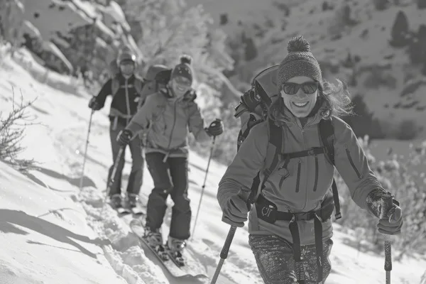
Expedition Preparation and Team Overview
Embarking on an expedition to conquer Barbeau Peak required meticulous planning and preparation by the Summits of Canada Expedition team. Months of groundwork were laid to ensure the success and safety of the journey to the remote Arctic archipelago. Let’s take a closer look at how the team got ready for this epic adventure.
Planning and Logistics
Planning for the expedition began well in advance, with the team carefully mapping out the route, assessing risks, and organizing logistics. They meticulously calculated the supplies needed for the journey, considering factors like food, equipment, and fuel for survival in the harsh Arctic environment.
Training and Preparation
Each member of the expedition team underwent rigorous training to build the necessary skills and endurance for the challenging trek ahead. Training sessions included physical conditioning, wilderness survival techniques, cold weather preparedness, and navigation skills to navigate the treacherous terrain of the Arctic.
Key Members of the Team
The Summits of Canada Expedition team comprised seasoned adventurers, each bringing unique skills and experience to the table. Among the key members were:
- Expedition Leader: Responsible for overseeing all aspects of the journey, coordinating logistics, and ensuring the safety of the team.
- Mountaineers: Experienced climbers tasked with leading the ascent to Barbeau Peak and navigating challenging terrain.
- Survival Experts: Trained wilderness experts equipped to handle emergencies, provide first aid, and ensure the team’s well-being in extreme conditions.
- Documentary Team: Dedicated filmmakers and photographers tasked with capturing the expedition’s highs and lows, documenting the journey for posterity.
Roles Within the Expedition
Each team member played a vital role in the success of the expedition:
- Navigation: Guiding the team through uncharted territory, using maps, compasses, and GPS technology to plot the course.
- Supply Management: Ensuring the team had an ample supply of food, water, fuel, and equipment to sustain them throughout the journey.
- Communication: Maintaining contact with base camps, support teams, and emergency services, using satellite phones and radios to stay connected.
- Motivation and Morale: Keeping spirits high during challenging moments, offering encouragement and support to fellow team members.
With thorough preparation, a skilled team, and a shared sense of determination, the Summits of Canada Expedition was poised to conquer Barbeau Peak and make history.
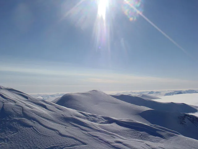
Barbeau Peak: A Landmark of Nunavut’s Majesty
Nestled amidst the Arctic splendor of Nunavut, Barbeau Peak emerges as a towering testament to the untamed wilderness of Canada’s northernmost territory. This geological marvel not only graces the landscape with its lofty presence but also holds profound cultural significance for the region’s Indigenous peoples.
Geological Marvels
Rising majestically within the British Empire Range of Quttinirpaaq National Park on Ellesmere Island, Barbeau Peak stands as a sentinel of the Arctic, its snow-capped summit piercing the sky. Its rugged façade, adorned with icy glaciers and sheer cliffs, presents a formidable challenge to intrepid adventurers seeking to conquer its heights.
Barbeau Peak’s rocky slopes and crevassed glaciers weave a tale of geological wonders, offering a glimpse into the ancient forces that shaped this remote landscape. Each jagged crag and glistening icefall bears witness to the enduring power of nature, inviting explorers to unravel its mysteries.
Cultural Reverence
Beyond its geological splendor, Barbeau Peak holds a place of reverence in the hearts of Nunavut’s Indigenous communities. Named in honor of Dr. Marius Barbeau, a pioneering ethnographer who dedicated his life to preserving Indigenous traditions, the peak embodies a profound connection to the land and its people.
For the Inuit and other Indigenous inhabitants of Nunavut, Barbeau Peak serves as a beacon of cultural heritage, echoing with tales of resilience and adaptation in the face of Arctic adversity. Its towering silhouette stands as a testament to the enduring bond between humanity and the harsh yet beautiful Arctic landscape.
A Legacy of Exploration
Throughout history, Barbeau Peak has beckoned explorers and adventurers to its icy embrace, each expedition leaving a mark on the annals of Arctic exploration. From pioneering scientific missions to daring summit attempts, these endeavors have enriched our understanding of the Arctic’s fragile ecosystem and its vital role in the global environment.
As modern-day adventurers continue to heed the call of Barbeau Peak, they pay homage to those who came before them, honoring the legacy of exploration and discovery that defines this remote corner of the world. With each step taken in its shadow, they forge new pathways of knowledge and appreciation for Nunavut’s unparalleled beauty.
Challenges and Precautions
Venturing into Canada’s remote Arctic archipelago presents explorers with a myriad of challenges, from navigating treacherous terrain to braving extreme weather conditions. As the Summits of Canada Expedition prepares to embark on their journey to Barbeau Peak, they must carefully consider the unique hazards of Arctic exploration and take precautionary measures to ensure their safety and success.
Extreme Weather Conditions
The Arctic environment is notorious for its unpredictable and harsh weather conditions, with temperatures plummeting well below freezing and fierce winds sweeping across the icy landscape. These extreme weather phenomena pose a significant threat to expedition members, increasing the risk of frostbite, hypothermia, and other cold-related injuries.
To mitigate the impact of Arctic weather, the expedition participants must equip themselves with specialized gear designed to withstand sub-zero temperatures and high winds. This includes insulated clothing, sturdy footwear, and protective outerwear to shield against the elements. Additionally, they must remain vigilant and monitor weather forecasts closely, adjusting their itinerary as necessary to avoid exposure to hazardous conditions.
Logistical Considerations
Logistics pose another formidable challenge in Arctic exploration, as the remote and isolated nature of the region presents obstacles to transportation, communication, and supply management. The expedition team must meticulously plan their route, accounting for factors such as distance, terrain, and accessibility.
In addition to logistical planning, the participants must also establish reliable communication channels to maintain contact with base camps and emergency response services. Satellite phones, GPS devices, and two-way radios are essential tools for staying connected in the vast expanse of the Arctic wilderness.
Safety Measures
Ensuring the safety of expedition members is paramount in Arctic exploration, requiring strict adherence to safety protocols and emergency procedures. The participants undergo rigorous training in wilderness survival, first aid, and navigation techniques to prepare for unforeseen emergencies.
Before setting out on their journey, the expedition participants conduct thorough risk assessments and develop contingency plans for potential hazards such as avalanches, crevasse falls, and polar bear encounters. They carry essential safety equipment, including avalanche beacons, ice axes, and bear deterrents, and practice effective communication and teamwork to respond to emergencies swiftly and effectively.
By prioritizing safety and taking proactive measures to mitigate risks, the Summits of Canada Expedition participants endeavor to navigate the challenges of Arctic exploration successfully, forging ahead with confidence and determination as they pursue their quest to conquer Barbeau Peak.
Conclusion
The Summits of Canada Expedition embarks on a historic journey to conquer Barbeau Peak, the highest point in Nunavut, marking the culmination of an 11-year adventure learning project. Thorough planning and logistics preparation were essential for the success and safety of the expedition, with meticulous calculations of supplies and rigorous training for team members. Barbeau Peak, nestled in Nunavut’s remote Arctic archipelago, stands as a geological marvel and holds profound cultural significance for Indigenous communities, echoing tales of resilience and connection to the land. Arctic exploration presents unique challenges, including extreme weather conditions, logistical hurdles, and safety concerns, requiring careful consideration and precautionary measures by the expedition team. By prioritizing safety and taking proactive measures, the Summits of Canada Expedition aims to navigate the challenges of Arctic exploration successfully, honoring the legacy of exploration and discovery while forging new pathways of knowledge and appreciation for Nunavut’s unparalleled beauty.
FAQs
What is the Summits of Canada Expedition?
The Summits of Canada Expedition is a historic journey aimed at conquering the highest points in every province and territory of Canada.
How did the team prepare for the expedition?
The team meticulously planned and prepared for the expedition by conducting thorough logistics assessments, calculating supplies, and undergoing rigorous training to build the necessary skills for the challenging trek ahead.
What is the significance of Barbeau Peak?
Barbeau Peak holds profound cultural significance as the highest point in Nunavut, embodying a connection to the land and its Indigenous communities. It also serves as a geological marvel in Nunavut’s remote Arctic archipelago.
What are the unique challenges of Arctic exploration?
Arctic exploration presents challenges such as extreme weather conditions, logistical hurdles, and safety concerns due to the remote and isolated nature of the region.
How does the expedition prioritize safety?
The expedition prioritizes safety by conducting thorough risk assessments, developing contingency plans, and equipping team members with essential safety equipment and training in wilderness survival and first aid.