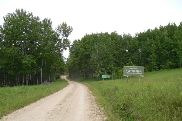
The highest point of land in Saskatchewan, the Cypress Hills are covered with pine forests, grasslands and rare wildflowers. The main entrance to the Centre Block of the Cypress Hills Interprovincial Park lies about 25 kilometers northwest of the Spring Valley Guest Ranch.

Canada’s first and only Inter-Provincial Park
Cypress Hills. 1,392 metres. 4,567 feet
| Attribute | Details |
|---|---|
| Altitude | 1,392 m, 4,567 ft |
| Location | 49° 40′ 00” N – 109° 30′ 00” W, 49° 33′ N, 109° 59′ W |
| NTS Map | 072 F/11 |
| Calendar | N/A |
| Parks | Cypress Hill Inter Provincial Park |
| Fast Facts | CAPITAL: Regina, Saskatchewan PROVINCIAL FLOWER: Western Red Lily PROVINCIAL BIRD: Sharp-tailed Grouse TREE: White Birch |
| Web Links | www.cd.gov.ab.ca www.peakbagger.com www.ocanada.com go.hrw.com www.sasktelwebsite.net www.hpedsb.on.ca www.virtualsk.com |
History
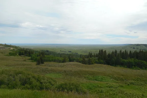
The highest point in Saskatchewan, an officially unnamed elevation in the Cypress Hills, rises to 1,392 metres near the Alberta border. (The Cypress Hills rise even higher, to 1,465 metres, farther west in Alberta.) Early French voyageurs identified the jack pine as a cyprès, and this was rendered as “Cypress” on the map of the Palliser report of 1857-60.
The highest spot (1392 metres or 4567 ft. above sea level) is in the Cypress Hills in the southwest corner of the province. The Cypress Hills are the highest point in Canada between the Rocky Mountains & Labrador.
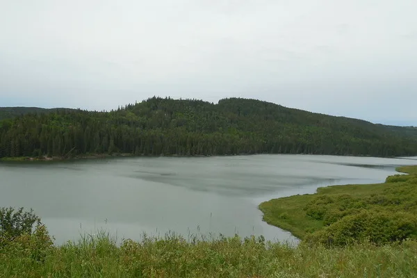
Cypress Hills has always been a lush retreat, rich in wildlife. For at least 7,000 years, nomadic Plains Indians wintered here because the hills were an excellent source of food, fuel, furs and building materials – lodgepole pines made excellent travois, teepee poles and, as their name implies, lodges. An additional attraction for the Indians was the Chinook breeze from the west, which made for a much milder winter than the one experienced on the Great Plains below.
Автор: Jimmy Emerson – flickr.com
Climate and Weather
Exploring the climate and weather of Cypress Hills unveils a fascinating tale of nature’s diverse moods, shaped by the region’s elevation and geographical positioning. Here, visitors can escape the monotony of the surrounding prairies and immerse themselves in a realm of climatic diversity.
Average Temperatures
Embarking on a journey through Cypress Hills means encountering a spectrum of temperatures that reflect the changing seasons. In the summer months (June to August), the hills bask in warmth, with daytime temperatures ranging from a pleasant 15°C to 25°C (59°F to 77°F). This season invites adventurers to explore the outdoors, indulge in camping, and spot wildlife amidst the verdant landscape.
As autumn unfolds (September to November), temperatures gradually descend, offering a crisp ambiance with daytime highs hovering between 5°C to 15°C (41°F to 59°F). The hills adorn themselves in a vibrant cloak of fall foliage, creating a picturesque backdrop for leisurely strolls and reflective moments.
Winter casts its icy spell upon Cypress Hills (December to February), bringing with it chilly temperatures and a blanket of snow. Daytime highs dip to -5°C to -15°C (23°F to 5°F), while nighttime lows plummet below -20°C (-4°F). Yet, amidst the frosty embrace, the hills beckon adventurers to partake in exhilarating activities such as cross-country skiing and ice fishing.
With the arrival of spring (March to May), the hills awaken from their wintry slumber, embracing a gentle warmth with temperatures ranging from 0°C to 10°C (32°F to 50°F). The landscape undergoes a breathtaking transformation as snow gives way to lush greenery and vibrant wildflowers, signaling the onset of a new season of exploration and rejuvenation.
Precipitation Levels
Rainfall in Cypress Hills is a harmonious symphony that plays throughout the year, with each season contributing its own unique rhythm. Annual precipitation averages between 400 to 600 millimeters (16 to 24 inches), with snowfall adding its own ethereal touch to the winter landscape.
Seasonal Considerations
Planning a sojourn to Cypress Hills necessitates an understanding of the nuances of each season and its impact on the landscape. Visitors are encouraged to pack accordingly, with layers to combat the chill of winter and lightweight attire for the balmy days of summer.
During the summer months, insect repellent becomes a trusted companion, warding off pesky mosquitoes and ensuring uninterrupted enjoyment of the outdoors. In winter, travelers should be prepared for possible road closures due to snowfall, adding a touch of adventure to their snowy escapades.
In essence, Cypress Hills offers a tapestry of climatic experiences that invite exploration and discovery throughout the year. Whether it’s the fiery hues of autumn or the serene beauty of a winter wonderland, each season unveils a new chapter in the captivating tale of Cypress Hills.
Автор: Jimmy Emerson – flickr.com
Safety Tips and Regulations
Embarking on an adventure in Cypress Hills comes with the responsibility of understanding and adhering to safety guidelines and park regulations.
Hiking and Camping
- Prioritize safety by planning your hiking route beforehand and sharing your itinerary with a trusted individual.
- Stick to marked trails to avoid getting disoriented and to protect the delicate ecosystem.
- Equip yourself with essential supplies like water, snacks, a map, and a well-stocked first-aid kit.
- Dress appropriately for the terrain and weather conditions, ensuring you have sturdy footwear and layered clothing.
- When camping, pitch your tent only in designated areas and adhere to Leave No Trace principles to minimize environmental impact.
- Keep food securely stored to deter wildlife from wandering into your campsite, and properly dispose of waste in designated bins.
Wildlife Encounters
- Observe wildlife from a safe distance, refraining from approaching or feeding them to prevent disturbances and potential harm.
- Show respect for wildlife habitats by refraining from disrupting their natural behaviors or habitats.
- Securely store food items to prevent attracting bears and other wildlife, reducing the risk of human-wildlife conflicts.
- Stay vigilant for ticks, taking precautions such as wearing protective clothing and using insect repellent to minimize the risk of tick-borne illnesses.
Park-Specific Rules and Regulations
- Adhere to all posted signs and regulations within the park, including guidelines for activities like fishing, boating, and hunting.
- Respect designated quiet hours and other rules established to maintain a peaceful atmosphere for all visitors.
- Comply with any fire bans or restrictions in place, utilizing designated fire pits for campfires and exercising caution to prevent wildfires.
- Keep pets leashed at all times and clean up after them to safeguard the well-being of wildlife and fellow visitors.
By embracing these safety tips and regulations, you not only safeguard yourself and fellow adventurers but also contribute to the preservation of Cypress Hills’ natural splendor for future generations to enjoy.
Author: Jimmy Emerson – flickr.com
Conclusion
Discover the diverse beauty of Cypress Hills, Saskatchewan’s highest point, boasting enchanting landscapes of pine forests, sprawling grasslands, and rare wildflowers. Unveil the allure of Canada’s inaugural Inter-Provincial Park, Cypress Hills, standing tall at an elevation of 1,392 meters (4,567 feet), offering a haven for nature enthusiasts and history buffs alike. Delve into the rich tapestry of history spanning over 7,000 years, as nomadic Plains Indians sought refuge in Cypress Hills during winter, drawn by its abundance of resources and milder climate. Experience the kaleidoscope of climates throughout the year, from the sun-kissed warmth of summers, perfect for outdoor adventures, to the snow-laden winters, ideal for thrilling pursuits like skiing and ice fishing. Embrace a culture of safety by meticulously planning hiking routes, respecting park regulations, and exercising caution during wildlife encounters, ensuring a memorable and responsible visit to Cypress Hills.
FAQs
What are the main attractions of Cypress Hills?
Discover the enchanting landscapes of Cypress Hills, including its pine forests, sprawling grasslands, and rare wildflowers. Learn about the region’s rich history and explore historical sites.
How high is Cypress Hills?
Cypress Hills stands tall at an elevation of 1,392 meters (4,567 feet), making it the highest point in Saskatchewan and Canada’s inaugural Inter-Provincial Park.
What activities can I enjoy in Cypress Hills?
Cypress Hills offers a wide range of outdoor activities throughout the year. From hiking and camping in the summer to skiing and ice fishing in the winter, there’s something for every adventurer.
Are there accommodations available in Cypress Hills?
Yes, Cypress Hills provides various accommodation options, including campgrounds, cabins, and lodges, catering to different preferences and budgets.
Is wildlife viewing common in Cypress Hills?
Wildlife viewing is a popular activity in Cypress Hills, with opportunities to spot deer, elk, bears, and various bird species. Visitors should exercise caution and maintain a safe distance from wildlife.